Vertical aerial photography is invaluable for capturing geographical information that informs everything from mapping and asset condition to elevation data and change-detection. It wasn’t long after the birth of photography that someone thought to capture an image from the skies. The earliest aerial photographers used balloons, kites, rockets and even pigeons to carry their cameras.

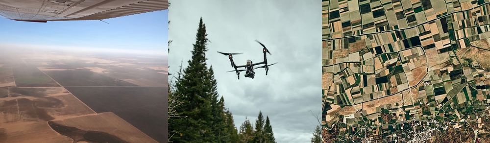
Wilbur Wright piloted the first manned aircraft to capture an aerial photograph in 1909. We still use fixed-wing manned aircraft to carry cameras into the skies today, but their technology has advanced greatly. The information collected goes far beyond pictures, providing a plethora of data that starts with beautiful imagery. But not all aerial photographs are created equally. Today, vertical imagery used for GIS (geographic information system) purposes is mostly done from one of three vehicles: manned aircraft (piloted airplanes), unmanned aerial vehicles and satellites. Although each has its unique value and purpose, the precision of data that can be captured and the costs associated should be considered when deciding your needs. However, keep in mind that it’s not necessarily an either/or situation. These technologies can be complementary.
Satellite Imagery

Satellite images are what people find most familiar in terms of vertical geographical imagery, thanks to Google and Bing maps. The first satellites were sent into orbit in the 1950s and today hundreds of Earth Observing Satellites are in orbit around our planet with their sensors and cameras pointed back at us. The information they provide helps us to understand our planet, its geographical features and climate. People often think that with so many satellites it would be easy to obtain specific and detailed aerial imagery of almost anything or any place on Earth. It’s not. There are a few challenges with satellite imagery. First, there is the problem of what information is made available to the public. Although satellite technology exists for capturing detailed and real-time data, that data is mostly owned by governments. Regulations around privacy and national security limit what most people can access, which is mostly dated and low-resolution imagery. There is also the issue of time lag between vertical data being captured by a satellite and the image being made available. That data can be weeks, months or even years old. Satellites generally do a sweep of a particular area every couple of years. Someone looking for signs of recent land erosion or pipeline leaks won’t find satellite imagery useful. Not to mention the issue of clouds that can block views. The cost of satellite imagery can be prohibitive. Small companies often find it hard to get what they need. Satellite images are licensed by brokers who are not motivated to work with customers that only require imagery of small areas. Satellite imagery is good for a broad view of a very large area that doesn’t require fine resolution.
Unmanned Aerial Vehicle Imagery (Drone Aerial Photography Aircraft)

Unmanned aerial vehicles (UAVs), frequently referred to as drones, have been used since World War II for both military and commercial use. As the name suggests, UAVs don’t have pilots on board. However, they do require licensed operators on the ground that know what they’re doing. Drones are very special to me because that’s where I started my career in aerial imagery. Those little flying robots are just the coolest thing, but UAVs are heavily regulated due to aviation safety and privacy concerns. You need direct access to the property you want to survey and all the permissions that go along with that. The real positive about drones is that they can provide very high-quality data because of the low altitudes they are capable of. UAVs can be very tactical. If you know where you need very detailed imagery captured, you can send in a drone team. that can record very specific data. But if you have a project of a larger size or scope, it’s really not feasible for most companies to use UAVs in today’s regulatory environment. The cost is typically prohibitive due to the man-hours and all the permissions needed.
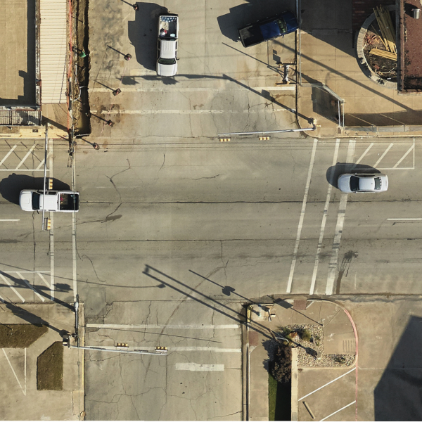
Manned Aircraft Imagery

Manned aircraft are just as significant for capturing aerial imagery and data today as they were in the days of the Wright brothers, who literally took aerial photography to the next altitude. Although not all operators do this, the right aerial imagery provider will carry advanced equipment that can provide very high resolution and cover extensive distances in a cost-effective way. Airplanes can cover a lot of ground very quickly. That’s a lot of data potentially being captured in a relatively short amount of time – not just visual data, but also elevations and other geographical information. Manned aircraft are also more weather and wind resilient. It is not uncommon for imagery to be needed in areas with sustained winds over 35 miles per hour. Winds like that would all but ground most UAVs due to the operating limitations of an unmanned aircraft. A company with in-house drone capabilities and hundreds of miles to cover would find it more feasible and economical to start with a broader, manned aerial survey to identify small areas that need closer examination by drone. This approach can make it possible for engineering firms to provide cost-effective imagery for their customers and multiply their own UAV imagery utility. Using unmanned vehicles with this approach provides a very clear and repeatable return on investment.
Manned aircraft imagery can be invaluable for things like detecting leaks along a pipeline or for an aerial survey of a vast area of land. Manned aircraft mapping is another preferred capability of planes vs drones. It’s a great solution for engineering firms, land service companies and just about anyone with an interest in understanding a piece of property or area of land. If you are trying to monitor and ensure the viability of a location-based asset, aerial imagery can make that much easier and more efficient. And with working from home so common, assets can be monitored from a desktop in an employee’s home office. Although manned aircraft aerial imagery is a stand-alone solution, it can also be complementary to UAV and satellite.
Manned Aircraft Imagery Vs. Satellite Imagery

At the end of the day, there is a place and a use for wide area satellite imagery, strategic, manned aircraft geographical data and surgically placed UAV/drone coverage. Satellite images can give you a very broad understanding of a region. Manned aircraft can be used to pinpoint problems across long distances and identify with precision those small areas you might want to surgically insert a drone team. The sky’s the limit with all the advanced aerial imagery technology available, but it all starts with knowing your budget, along with how fresh and detailed you want the data to be. If you have questions about aerial imagery or would like some help understanding how it can benefit your business, please don’t hesitate to reach out to us. We’re always ready to help leaders find solutions. GET IN TOUCH